Norman Wells- Part One
Welcome Sign

Monday, July 20th 2015/ 11:43pm / 20˚C
When arriving in Norman Wells, this will be one of the first things you’ll find. What says ‘welcome’ better than a massive raven? Along with this sign, every sign in Norman Wells is in the shape of a raven.
Links:
Sahtu Secretariat IncorporatedInukshuk

Thursday September 3rd, 2015/ 5:15pm/ 9˚C
The inukshuk is a symbol of northern Canada which was traditionally used to convey that ‘someone was here’ or ‘you are on the right path’. The Nested Rossdale Seraph functions as a face to this inukshuk at DOT Lake in Norman Wells of the Sahtu region, Northwest Territories. This small community is nestled on the banks of the Mackenzie River in the valley between the Mackenzie and Franklin Mountains (visible in the photo). Dene First Nations people maintain oral histories connected to the landmarks of the Sahtu, such as Bear Rock. Alexander Mackenzie also took note of landscape of the area in his eighteenth century explorations. There was an increased interest in prosperous oil production of Norman Wells during World War II. Still, Mackenzie’s records reveal that Dene people were using the natural oil to waterproof their canoes. The multifaceted history of Norman Wells is part of the reason that this unique community is such an interesting and gratifying place to live.
Links:
Carcajou Avenue

Friday July 17th, 2015/ 2:20pm/17˚C
My summer co-worker and former classmate tells me that the raven is a very important bird for Dene people, an aboriginal group that lives in Northern Canada. He told me about a man who once killed a raven and consequentially was unable to hunt successfully after that for years. The ravens mark all our streets. I didn’t know all the names of my hometown until I registered to vote this year. To enter my address, I had to pick from a scroll down list of twenty-three street names: Beaver Lane, Otter Road, Forestry Drive, and so on.
Community

Thursday June 4th, 2015/ 1:30pm/ 13˚C
I like living in Norman Wells because it is a tight knit community.
Mackenzie Ice

Thursday June 4th, 2015/ 1:30pm/ 13˚C
I live in one of the most beautiful places in the world. It is a town of eight hundred people located in the Mackenzie valley, surrounded by trees, mountains and lakes. It is a town that is not only filled with the friendliest people in the world, but some of the most artistic ones as well. Everyday, I have the pleasure to have new experiences and see new sights that I will never forget, all with the company of my many wonderful friends.
Coast Guard Dock

Monday June 29th, 2015/ 5:45pm/ 26˚C
This rock portrait was taken on the bank of the Mackenzie River at Norman Wells, NWT, Canada. The river is an integral part of the community and a lifeline for the people. The river brings food and supplies to our remote community, which has no road connecting it to the outside world. Stones, fossils and carvings living as one --this arrangement is for me, just like the Sahtu people, multi-coloured, multi-textured and multicultural.
Pumpjack

Thursday July 16th, 2015/ 6:05pm/ 20˚C
There are a few pumpjacks to be found around town. I’ve heard them called gas hoppers, but they have many nicknames: oil horse, thirsty bird, and dinosaur, to name a few. They are an apparatus used to draw liquid out of wells. The pumpjacks are just one of the clues that reveals the primary industry of this community. In both Slavey and English the name of the town points to the abundance of oil in this area. The name “Norman Wells” refers to the oil that Alexander Mackenzie noted when he explored 0the area in the 18th century. Imperial Oil drilled the first well of Norman Wells in 1919. The former half of the name alludes to the nearby community Fort Norman, known today as Tulita. Fort Norman was a Hudson Bay Fort that evolved into a community. “Norman" is likely a tribute to either Alexander Norman McLeod or Archibald Norman McLeod, individuals who were very involved with the fur trade of early Canada. Meanwhile, the Slavey name for Norman Wells is “Le Gohlini” which translates to “ where the oil is”.
Links:
Alexander Mackenzie

Thursday June 4th, 2015/ 1:30pm/ 13˚C
The Mackenzie is the world’s eleventh longest river stretching about two thousand six hundred miles. In fact, it is the largest river in Canada. Wildlife that can normally be found along the river’s marshy delta includes snow geese and tundra swans. The Mackenzie River is named after the Scottish-Canadian explorer Alexander Mackenzie. Mackenzie travelled the river while trying to reach the Pacific Ocean.
Links:
The Mackenzie River

Thursday June 4th, 2015/ 1:30pm/ 13˚C
The Mackenzie River is the largest and longest river in Canada. It is also the second largest in all of North America only being succeeded by the Mississippi River. The Mackenzie River offers marvelous views although it is also dangerous. Its strong currents are dangerous for swimming, canoeing, or kayaking. The fresh water supplies surrounding areas with drinking water. The great waters freeze over every year, allowing us to use our winter road to bring in more supplies. Once it melts again in the summer, not only is it a spectacular thing to see, but also it allows barges up with groceries and other goods.
Town Square

Wednesday July 22nd, 2015/ 3:30pm/ 17˚C
Wood Buffalo went down to Town Square in Norman Wells to visit the new Northern Store built last summer. Wood Buffalo also got a quick peek of the restaurant (on the right) called the Yamouri. We didn’t stay to eat, but we were tempted by the delicious smell of the food. The weather was nice, a breezy mixture of sun and cloud. It started to rain lightly but we weren’t worried because there weren’t too many dark clouds above us. The rain passed within five minutes. Wood Buffalo likes Norman Wells. There is a lot of beautiful plants and wildlife, along with friendly people. Wood Buffalo thinks Norman Wells is a cute and quiet place to live if you are looking to get away from city life.
Memories

Wednesday July 22nd, 2015/ 2:45pm/ 17˚C
This photo was taken in Town Square. I have lived here for thirteen years now so I should have a ton of memories here. I remember a time when my friends and I were playing hide n’ seek and some of us were hiding under the long deck near the Yamouri because there is a door underneath. One of the kids ratted us out to the owner. They got mad at us so we ran out and booked it somewhere else. Good times.
Who is Mary?

Wednesday July 22nd, 2015/ 3:00pm/ 17˚C
This photo was taken in a store in Norman Wells. There are only four stores here and only two sell food. The store I took this photo in is called Mary’s Store. Who is Mary? I don’t know because she owned the store way before I was born. The real name is Rampart Rentals but everyone just calls it Mary’s Store.
Northern Nutrition

Friday May 29th, 2015/ 7:25pm/ 24˚C
It is rather discouraging going to the grocery store to see that the majority of the produce counter is empty. The Government of Canada introduced the Nutrition North Canada program that was suppose to improve access to perishable nutritious food in the three Territories of Canada. The 2009 report from Statistics Canada states that the average household expenditure on food in Canada was $7,262 whereas it was $7,496 in the Yukon, $9,509 in the Northwest Territories and $14,815 in Nunavut. In a CBC North article, people have stated for years that this program wasn’t working and had to wait until the Auditor General’s report of August 19, 2014. The report highlighted several problems of the program and finally the issue was taken seriously. If I want baby carrots, I have to be willing to pay $3.59 for a 454 gm bag. A small head of cauliflower costs $9.45 and I shell out $5.09 for a package of celery hearts. The cost of groceries is high because fresh food is shipped by air and the dry goods come by barge during a very limited season. I would be willing to pay those prices if the groceries were available. When I visit a grocery store in the Southern Canada, I lust after the variety and full counters of reasonable priced fruits and vegetables. Bon appétit.
Links:
CBC News - Nutrition North food subsidy program: What went wrong
Boat Ride

Monday June 29th, 2015/ 12:00pm/ 29˚C
It was a hot day in Norman Wells, NT. Hibernation Pescador was invited to take a scenic boat ride down the Mackenzie River. She was very exited by this opportunity as it was sweltering and Hibernation Pescador figured it would probably be somewhat cooler on the river with the wind blowing around her. At noon, she met up with her friends, Sh and J to board the boat. Sh and J brought along some lemonade and a bag of chips for a snack. Sh is an experienced boat person, so neither J or Hibernation Pescador were concerned being in the boat with Sh steering. The friends traveled up and down the Mackenzie River. Hibernation Pescador had the chance to see the view from the river and was amazed with the beautiful scenery. She got to see MacKinnon Park from the riverside, which was equally as beautiful as when she recently visited the park itself. Hibernation Pescador was appreciative of the cool breeze that ran across her. She was finally experiencing some relief from the heat. Hibernation Pescador even casted a fishing line, although she wasn’t lucky enough to catch a fish. She had a wonderful time exploring the Mackenzie River, Canada’s largest river. She will never forget this experience.
Life Jackets

Thursday June 4th, 2015/ 1:30pm/ 13˚C
Mackenzie River is a majestic river. It is 1800 km long and it ranges from 2 to 5 km wide. Norman Wells is located at one of widest portions of the river; it is so wide that many visitors have asked if we live on the banks of a lake. Another special feature of the Mackenzie River is that it is part of the Trans Canada Trail. In the summer many people use it for recreation purposes such as canoeing while in the winter, it becomes a part of the winter ice road. The river is a magnificent river yet it is a river requires respect. I’ve known at least three people who have perished in the Mackenzie River in the last ten years. The community has responded to these tragedies by placing a tree of life jackets that are available to anyone who is traveling on the river. The only stipulation is that the life jackets are returned to the tree so that others may use them. Hopefully there will no more tragedies on the Mackenzie River.
Links:
Bear Rock

Monday July 20th, 2015/ 2:00pm/ 16˚C
On July 20th 2015, Yorkino Fish Boat and Habanero Sail Marlin accompanied the Education Culture and Employment team to Tulita, Northwest Territories: Deputy Minister D, Assistant Deputy Minister A, Assistant Deputy Minister R, Captain T, Regional Manager Income Security J, Regional Employment Officer C, and myself Associate Regional Superintendent T. We travelled by boat from Norman Wells to Tulita and at approximately 14:00 hrs MST we passed Bear Rock. The afternoon boat ride started out choppy with rain clouds drifting in and out but for the most part is was a sunny day, plus 16 degrees Celsius. Bear Rock has significant meaning to Sahtu Dene and Métis people. It is the place where Yamouria (Yamoria) laid out three giant beaver pelts to dry. The giant beavers were killed as they were menacing the lives of the Dene people in the Sahtu region. The significance of this picture is the fact that no matter how busy we are in our lives me must take time to reflect and marvel the natural wonders of the land and pay respect to the valuable teachings of our people.
Links:
The Raft

Thursday July 23rd, 2015/ 6:15pm/ 18˚C
M and A, two men from Winnipeg, built this raft and are traveling up the Mackenzie River. I met them yesterday on the porch outside of the Yamouri. The Yamouri is a restaurant, named after a legendary Dene hero, located in Town Square. At the time, their raft was docked outside of a town at the McKinnon Park. They had hitchhiked into Norman Wells and were smoking a cigarette and chatting with some local people. I asked if they would borrow Ms. Stacks to take back to their raft to take some photos. At first they agreed but then realized that they might be moving on the next day and didn’t want to make Ms. Stacks an unwilling passenger. This evening my colleague ran into M and A. They told her that they were docked nearby my house but would be leaving shortly. I got the message just in time to run down to the river and catch this photo as they were drifting away.
The Airport

Monday July 20th, 2015/ 11:44pm/ 20˚C
For a town of eight hundred people you wouldn’t imagine we would have such a big airport. It was opened in the early 90s. It is the home of Canadian North and North Wright. From here you can fly to Yellowknife, Edmonton and Inuvik. You can also fly to other communities within the region.
Links:
North Wright Airways

Friday May 8th, 2015/ 8:58am/ 1˚C
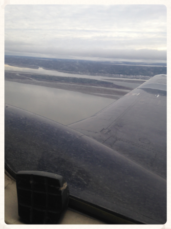
Norman Wells is the major center of the Sahtu Region in the Northwest Territories. During the months of December to March, we can travel to the other communities by the winter road. During the other times of the year, when the river is open, we can travel by boat to some of the other communities but the main mode of transport is via air. The smallest of the planes seats four and the largest plane seats nineteen. Flying on these small planes allows us to view and appreciate the landscape. I love looking out the window at the landscape. Occasionally, we can see caribou, Dall sheep, and geese. Food, freight, mail and just about anything else that can fit on the planes is transported to the communities by air. Today we flew on the plane that seats twelve. Flying from Norman Wells to Tulita takes approximately twenty minutes on this plane, which isn’t quite long enough for a nap.
Links:
The Winter Road

Monday July 20th, 2015/ 12:08pm/ 20˚C
This is a picture of the Winter Road... during the summer months. There is a reason why ‘winter’ is part of this name. About four to five months of every year this road is used to connect all five communities within the Sahtu. It makes for another way to travel outside of the town, and brings in more workers for the companies in the community. It’s quite popular once it’s open for the winter months.
DOT Lake

Saturday June 20th, 2015/ 4:45pm/ 26˚C
DOT (Department of Transportation) Lake is a man made lake made for plane landings. Although it is a great view, the fresh waters are filled with leeches, oil and gas. The lake is not only for plane landings, but also canoe lessons for beginners. The lake has one end where many birds nest for the summer. There are seagulls, ducks and sometimes geese.
Dall Sheep Skull

Thursday July 16th/ 5:45pm/ 18˚C
This is the skull of a Dall Sheep that was harvested about ten years ago from the Imperial River area in the Mackenzie Mountains, NT. The family that harvested this sheep are hunters. Wild game is seventy-five percent of their diet, so every bit of this sheep was utilized. Dall sheep is a species of sheep native to northwestern North American, ranging from white to slate brown in colour and having curved yellowish brownish horns.
Northwright Airways Flight to Deline
Tuesday October 13th, 2015/ 4:22pm
Northwright Airways is a small airline providing scheduled and chartered air transportation in the Sahtu and beyond has been operating since 1986. This particular flight to Deline has a stop in Tulita following the Mackenzie River which is the longest river in Canada at an estimated 1800 km. Along this river, it has been estimated that there could be up to 200 billion barrels of oil in the Sahtu area which could be beneficial to the local economies. With the controversial “fracking” technology that would have to be used to get the oil combined with low oil prices, just to name a few concerns, this oil may never be extracted. Flying to the all the communities for my work makes me wonder about the future of its residents and what the future holds for the younger generation. Oil is not the only industry that fuels the economy in the region but is indeed a big part of it. With the Territorial election this fall, all candidates for the regions MLA post agree that an all-weather highway would boost the economy of at least a few communities of the region. I have come to know many people over the course of my eight years in the Sahtu and truly hope that there will be development of some form that will benefit the communities to be able to live comfortable and happy lives.
Links:
Self Guided Trips - The Mackenzie River (Deh Cho)
CBC - NEB and GNWT study finds 200 billion barrels of oil in the Sahtu
BBC - What is fracking and why is it controversial?
CBC - N.W.T. now plans Mackenzie Valley Highway in 'phases'
CBC - Norman Wells election forum focuses on economy, education
Colville Lake, Northwest Territories

Thursday November 19th, 2015/ 12:29pm
Colville Lake is a small community of approximately 150 inhabitants, mostly of aboriginal descent. Most of the residents of K'ahbamitue (The Dene name for the community which translates to “Ptarmigan net”) are still very traditional where trapping is a common activity. The entire community goes out across the lake for the annual fall hunt. Amenities like indoor plumbing aren't in every house in the community and some still get their water from the lake rather than getting it delivered. Bern Will Brown made his home in 1960 where he built the first mission in the Community. He documented northern life by a wide variety of mediums (paintings, books, photos, etc.) and became well respected in the community and was considered one of the people even having learned the language. It makes me wonder how hard the reverse would be. To come from a very traditional community and try to find ones place in a more “modern” world. If the balance between the “modern” world such as cellphones, solar panels, and formal education and the traditional ways of life of trapping and fishing will be able to be achieved by the younger generation of the community. It can’t be easy being in between two very different worlds; one that seems to be of consumerism and the other being of conservation and sustainability. I hope that they will be able to find their place and bring with them the importance of the land for all of us.
Links:
CBC - Funeral for Bern Will Brown Tuesday in Colville Lake
CBC - Colville Lake, N.W.T., school struggles with attendance and funding
CBC - Colville Lake, N.W.T., turns to solar for reliable power
Like the Sound of a Drum: Aboriginal Cultural Politics in Denendeh and Nunavut